10. March 2025
Widespread Snow and Ice Disrupt Travel Across UK
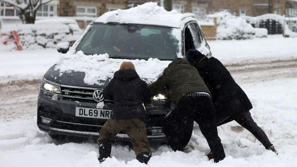
Commuters across the UK are facing potential delays as a period of cold weather persists, with many regions experiencing snowy and icy conditions on Wednesday morning.
Multiple yellow weather warnings for snow and ice have been issued by the Met Office for Wednesday, accompanied by a more serious amber warning scheduled for Thursday.
With arctic air dominating the UK, the UK Health Security Agency (UKHSA) has also activated yellow and amber cold-health alerts, remaining in effect until Saturday.
The risk of snow and ice is expected to decrease by the weekend as temperatures gradually rise.
Heavy snowfall was observed on Wednesday morning in County Durham
An area of precipitation, including rain, sleet, and snow, moved across the UK overnight into Wednesday, resulting in icy patches and a layer of snow in some areas.
The Met Office cautioned that “overnight ice could lead to hazardous travel conditions.” The agency highlighted that wintry weather creates dangerous driving situations, and road closures may occur, potentially stranding vehicles and passengers.
Darren Clark, a severe weather advisor for National Highways—responsible for England’s major roads—advised all drivers to perform “quick checks” on their vehicles, such as inspecting lights and tires, to “avoid being unprepared.”
He mentioned that over 530 gritters are on standby “when snow arrives or conditions require it.”
National Highways is coordinating with the Met Office, which has recommended that all motorists pack essential items like food, warm clothing, and a torch in case of delays.
Drivers using the A628 Woodhead Pass between Hollingworth and Flouch in Derbyshire should anticipate delays due to snowfall, according to National Highways.
Calmac ferries in Scotland have announced cancellations and potential disruptions due to “severe weather conditions.”
Bus and train services may also experience delays and cancellations.
Travelers are encouraged to check their routes in advance, monitor for delays or cancellations, and allow extra time for preparations and journeys.
Hilly regions in Wales, northern England, Northern Ireland, and Scotland are forecast to receive 2-5cm of accumulated snow, with higher elevations seeing more.
Throughout Wednesday, parts of south west Wales and south west England will continue to experience wintry showers, potentially causing disruptions from settling snow over elevated areas.
There is also a risk of ice on Wednesday, leading to multiple yellow Met Office weather warnings across the UK.
Frequent snow showers will persist in northern and eastern Scotland and north east England through Wednesday and into Thursday.
Met Office yellow warnings—active until 23:59 GMT on Thursday—suggest 2-5cm of snow at lower levels, with up to 15-20cm possible above 300m.
The North York Moors and sections of the Yorkshire Wolds could accumulate up to 25cm by Thursday.
An amber Met Office warning will be in effect from 05:00 to 21:00 GMT on Thursday in north east England.
This is expected to cause “significant disruptions,” including isolated rural communities, stranded vehicles, and potential power outages.
Strong winds may lead to blizzards and thundersnow, adding to the hazards.
Wednesday will feel particularly cold due to a brisk northerly wind.
Temperatures will range from 1-7°C, but wind chill will make it feel colder, especially in eastern UK regions.
Yellow cold-health alerts from the UKHSA are active across the Midlands until 08:00 GMT Saturday.
More severe amber alerts have been issued for North West, North East, Yorkshire and Humber for the same period.
These alerts primarily target health and social care services, warning of “substantial” impacts on vulnerable populations.
Services may face increased demands due to the colder conditions.
Colder weather often leads to excess deaths, particularly among those over 65 or with health issues. The UKHSA also notes potential impacts on younger age groups.
Thursday night is projected to be the coldest this week, with temperatures widely dropping below freezing and reaching -12°C in rural Scotland.
By Friday and the weekend, conditions will become less severe as Atlantic influences bring more cloud, some rain, and milder air.
Temperatures are expected to return to average by Saturday.